Monday 12 May 2008

Dredging


Vincent May Professor of coastal Geomorphology, put together a report in 2007 titled, IMPACTS ON BEACH AND CLIFF STABILITY ASSOCIATED WITH EXTRACTION OF SEDIMENTS FROM BEACHES AND OFFSHORE: UNDERSTANDING THE COMMUNITIES' RESPONSES TO PERCEIVED RISK" after a 4 day meeting took place in July 2007 to discuss a range of coastal concerns. In this report Vincent tried to assertain the nature and cause of the level of erosion happening around the British shoreline.

Having had this Dilemma since the 1900's a report by the Royal Commission on Coast Erosion (RCCE) in 1911 stated that the removal of sand and gravel from beaches appeared to cause an acceleration in the level of erosion.
Jump back to the present day and the level of aggregate dredging has risen dramatically. However the British Government seem convinced that although they are potentially removing thousands of tonnes of sand and stone from the seabed they see that as having no effect on the near by coastlines.

Bizarrely enough reading the report, seems to suggest that although this is occurring the evidence to conclusively say that marine aggregate dredging is contributing to the localised erosion of coastal zones does not exist.

Mullion Harbour


Located just North of the Lizard on the South coast of Cornwall, Mullion is one of the most attractive villages in the county. Because of this it attracted visitors from all around. Mullion harbour once a small fishing harbour now home to a few sailing vessels far from the commercialisation of Falmouth.

In 2004 a study of Mullion harbour was conducted to determine the viability of maintaining and protecting this picturesque place, from the horrors of winter storms and the ever impending fate of sea level rise.

from this 3 choices were presented to the mullion stake holder group which was set up by the National Trust.

The first choice of constructing an offshore breakwater was immediately dissmissed as being to costly and environmentally damaging.

The second option of maintaining and repairing the harbour walls and current defences was not dismissed, but seen as a solution to the temporary situation and thus combining it with the third option of leaving it to slowly fall away. This strategy will be adopted by the trust when the cost of annual maintenence is deemed no longer viable.

In 2006 work was carried out costing £150,000 to repair and restore the Harbour after the winter storms. From then until now the Harbour has been maintained and is still going strong.


Coastal Defences

Types of Coastal Defence.

Groynes
Groynes are cross-shore structures designed to reduce longshore transport on open beaches or to deflect nearshore currents within an estuary. On an open beach they are normally built as a series to influence a long section of shoreline that has been nourished or is managed by recycling. In an estuary they may be single structures.
Rock is often favoured as the construction material, but timber or gabions can be used for temporary structures of varying life expectancies (timber: 10-25 years, gabions: 1-5 years). Groynes are often used in combination with revetments to provide a high level of erosion protection.


Sea wall
Seawalls are impermeable structures designed to provide a defence against the action of the sea. They are often made of concrete and vary in shape depending on when they were designed and the local conditions. Some will have vertical walls that tends to result in spray coming over the wall and can have a detrimental effect upon the beach by reducing its height. Others will have a slope leading up to a curved wall that is designed to reduce the size of the wave reaching the wall and then to reflect it back out to sea.


Riprap/Rock Armour
Large boulders, of 10 tonnes or more, are piled up along the shoreline to form a type of sea wall.
The rocks are dumped on top of eachother leaving gaps between them that allow water through. This disperses the energy of the waves and reduces their erosional power. They can be very effective.
he boulders must be large, strong and resistant to erosion. Granite and basalt are often used. Small or weak rocks would not be able to withstand the impact from the waves and would quickly be eroded.


Gabion Groynes
Large steel or stainless steel mesh cages that are filled with rocks.
They run down the beach, at right angles to the coastline.
They function in a similar way to wooden groynes.
Expected life span of 20 – 25 years if made from steel because they will rust. Stainless steel ones last much longer

Beach Nourishment
This replaces beach or cliff material that has been removed by erosion or longshore drift. Sand is either brought in from elsewhere, or transported back along a beach, usually once a year.In tourist areas this is often done during the spring after the winter storms and before the tourists arrive to enjoy the beach. Beach nourishment is a relatively inexpensive option it requires constant maintenance. The annual costs are lower than installing hard engineering options, but to keep replacing the beach material as it is washed away requires annual expenditure.

Managed Retreat (also doing nothing)
Engineers do nothing and the coast is allowed to suffer erosion, deposition and flooding naturally. This is an option considered when the land is of low value and there are no significant risks to the people. It is, of course, very inexpensive in the short term although if land erodes there may be a need to compensate people for the loss of businesses, land and homes.

The Coastal Zone

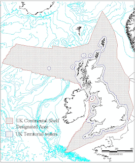
Uk territorial waters
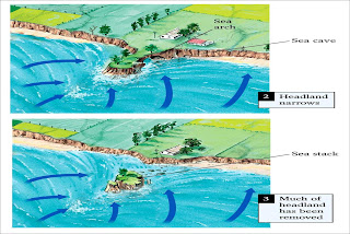

Baseline:- Lowest astronomical tide, Anything behind baseline is classed as internal waters.


Territorial Waters:- 12 nautical miles(nm) from the baseline, countries duristictions still apply here.


Contiguous Zone:- 12 nm from territorial waters, country has limited duristiction.


Exclusive Economic Zone (EEZ):- 200nm from baseline, can be extended to continental shelf. This is the region where exploitation of resources occurs.


What is the Coastal Zone??
The coastal Zone is defined as the region from the coastline potentially up to the 200 nautical mile line.


There is debate as to the true nature of the coastal zone as ecologically most life consists within the first 12nm of the baseline. and on the foreshore and shoreline, however due to the legislative process a country has rights up to the 200nm marker meaning that potentially they have to manage that entire distance.

Natural Processes

Climate Change

The true effects of climate change on the coastal environment are not accurately known at this time, because scientists can only guess at the likely impacts based on current global trends and past data configured from tests ranging from examining ice strata using core samples, to monitoring control/indicator species to see how they are being affected.

A good example of this would be the Pink Sea Fan found primarily in the Meditteranean region its upper limits are along the southern coasts of Cornwall and Wales. There is much debate as to the true extent climate change will affect coastal communities if it does at all.

Predicted Sea Level rise. The link to the left shows the result of sea level rise based on 7m, 13m and 84m rises in sea level.

Erosion

The typical erosion on the shoreline is due to tidal and wave action. Wave erosion occurs when deep water waves hit the shore with full force, also the moving of sediments and rocks along the shoreline can cause erosion to occur.

Hydraulic action tends to occur around cliff faces and Headlands as a mixture of water and air are forced in to cracks in the rock face, forcing the rock to splinter and shard. This can occur on the shoreline but in areas of rocky shore rather than sandy beaches. The sandy shore tends to suffer from what is termed long shore drift or a barrage of dumping waves if the topography of the sea floor is such to create them.


Tides/waves

Longshore current is produced as water flows parallel to coastline. Swash and backwash


Rip Currents are produced when water piles up in surf zones and flows seaward, generally perpendicular to the coast.


Daily rise/fall of surfaces of oceans/lakes due to gravitational pull of the
Moon/Sun on the Earth– also due to force created as Earth spins on its axis


Flood tides- elevate sea surface that cause shoreline to move inland

Ebb Tides- low sea surface that cause shoreline to move seaward


http://news.bbc.co.uk/1/hi/sci/tech/7191196.stm

http://www.aberdeencity.gov.uk/ACCI/nmsruntime/saveasdialog.asp?lID=2434&sID=904

Thursday 8 May 2008

Coastal Zone Management Terminology

JNCC:- (Joint Nature Conservation Committee)

"The Joint Nature Conservation Committee (JNCC) is the statutory adviser to Government on UK and international nature conservation. Its work contributes to maintaining and enriching biological diversity, conserving geological features and sustaining natural systems."

SSSI:- (Site of Special Scientific Interest)

SSSIs are the basic building block of site-based nature conservation and legislation. Most other legal natural/geological conservation designations in Great Britain are based upon them. they are given their designation by the Wildlife and Countryside Act 1981.

SAC:- (Special Area of Conservation)

These are strictly protected sites designated under the EC Habitats Directive. Article 3 of the Habitats Directive requires the establishment of a European network of important high-quality conservation sites that will make a significant contribution to conserving the 189 habitat types and 788 species identified in Annexes I and II of the Directive (as amended). The listed habitat types and species are those considered to be most in need of conservation at a European level (excluding birds). Of the Annex I habitat types, 78 are believed to occur in the UK. Of the Annex II species, 43 are native to, and normally resident in, the UK.

SPA:- (Special Protection Areas)

Special Protection Areas (SPAs) are strictly protected sites classified in accordance with Article 4 of the EC Directive on the conservation of wild birds (79/409/EEC), also known as the Birds Directive, which came into force in April 1979. They are classified for rare and vulnerable birds, listed in Annex I to the Birds Directive, and for regularly occurring migratory species.


NNR:- (National Nature Reserve)


The aim of an NNR is to secure protection and appropriate management of the most important areas of wildlife habitat, to provide a resource for scientific research and to provide a resource for recreation so long as this does not compromise the wildlife habitat. The majority of NNRs have some permitted access and schoolchildren and students are encouraged to venture in to help them learn about conservation management and see a range of wild animals and plants in their natural habitat.

The statutory purpose of NNRs was revised through the Natural Environment and Rural Communities (NERC) Act to formally recognise the important recreation role the reserves play.


NP:- (National Park)


National Parks are extensive areas each with their own managing authority to conserve and enhance their natural beauty, wildlife and cultural heritage and to promote opportunities for the understanding and enjoyment of their special qualities.

There are a total of 9 national parks in england
1. The Broads 2. Dartmoor 3. Exmoor 4. Lake District 5. New Forest 6. Northumberland 7. North York Moors 8. Peak District 9. South Downs 10. Yorkshire Dales


BMP:- (Beach Management Plan)

CORNWALL'S COAST
COAST ATLANTIC PROJECT
SITES
THEMES
Beach use
Beach Safety
Licensing Beach and Water Activity
Voluntary Codes of Conduct and Byelaws
ENVIRONMENTAL IMPACTS
Erosion
Beach Cleaning
Dogs
Invasive species
Climate change
PUBLIC PARTICIPATION AND AWARENESS
Surveys
Beach User Forum
Partnerships
Information
Education
Sustainable Tourism
MANAGEMENT FRAMEWORK
Legislation
Ownership and Responsibility
Partnerships
Management Plans
Organisational Structures
CONCLUSIONS

This is a report content from Cornwall county Council, outlining the key factors for managing a beach. http://www.cornwall.gov.uk/index.cfm?articleid=38834